 |
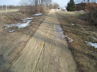
| GWT in March slop. |
 I better get splainin the weekend of riding before the next weekend gets here! Heh. As I was mentioning about those intended weekends of riding for the GIT, I decided it would be a good idea to first prove locally that I can withstand a weekend of riding similar to what I am planning.So this last Friday I decided to ride the Western half of the Great Western Trail. It starts in Sycamore and ends in St.Charles Illinois. That part of the trail is advertised as 18 miles long. Earlier in spring, way back in March, I had biked the Eastern seven miles of the trail and had found the trail kinda miserable at that time. People had been riding motorized vehicles on there in the fall and spring wet months, leaving ruts and divots in the trail. And parts of the trail really grabbed at the tires and sapped my energy quickly.
When I got to the trail head in Sycamore, the trail looked fairly quiet. So I hopped on my Montague/Swiss Bike TX Folding bike and began pedaling. There were some very interesting cement obelisk type mile markers in the Dekalb County part of the trail. The one shown in the pic has "C55" on it. Since it is only 18 miles to the end of the Western half of the GWT, I am assuming this refers to the distance to either Chicago or the Eastern end of the East half of the GWT. The interesting mile markers stopped once I entered Kane county. So the first nine miles of the trail were a loose almost sand sized gravel. The next two miles were paved. That was the area that includes the old railroad bridge over Rte. 47. It was weird that during that two miles of paved trail is when I got a chance to try out my newly installed Mister Tuffy strips in my tires. Something attempted to jam itself under my rear tire as I was cruising at about 17 mph. It gave the bike a jolt and I heard a loud pop. So I looked left to see something shoot out from under the tire and fly about 50 yards away. I thought I had a flat coming for sure. Shortly after that scare the trail returned to a sand mixed with clay for the rest of the trail. Here are the stats for the ride:
- Distance traveled 18.36 miles in total.
- Average speed 12.2 mph.
- Max speed 20.0 mph.
- Total ride time 1 hour 30 minutes 8 seconds.
- Actual time 1 hour 55 minutes.
- Trace path map of trail ridden
GWT and other trails on Google maps
Friends Of The Great Western Trails
I decided that 18.36 miles wasn't very representative of a typical day on the GIT that I am planning. And I still felt pretty energetic.So I decided to head across the street from the GWT trail end to Leroy Oaks Park.
 |
| Silver Glenn Rd. bike bridge. |
- Total distance round trip 22.09 miles.
- Average speed 10.9 mph.
- Max speed 27.9 mph.
- Total ride time 2 hours 56 seconds.
- Actual ride time 2 hours 20 minutes.
- Trace path map of trail ridden.
- The Google map has not been updated with the new Stearns Rd. Trail. So my path taken seems to show me in some areas without an apparent trail.
- Total distance traveled for the day was 40.45 miles.


You in much better shape than me GITerDone!
ReplyDeleteWhat makes you say that? You just have to get out there and try the miles. When you gonna plan out a trip down that local trail in your area? U should get Schert to do that too!
ReplyDelete