Total Pageviews

Tuesday, May 31, 2011

Falling Waters Trail


One of my friends from online intends to do this trail tomorrow. Here is the map. And here is the link to the webpage for the trail. I am interested in seeing other trails like this. Very kewl.

Sunday, May 22, 2011

GIT: DAY 1. CARPENTERSVILLE TO NAVY PIER IN CHICAGO


May 21, 2011. The first day of the GIT. The trail started for me at the intersection of Main St. and the Fox River Trail in Carpentersville, Illinois.

Saturday, May 21, 2011

Planned GIT Route For Day One


The day looks like I will have to pick a start time when the clouds clear for a minute. The plan is to take the FRT to the IPP and then 13 miles of Chicago streets to get to Navy Pier on the lakefront.  Here is the Google mapped route of the streets from the end of the IPP to Navy Pier.


If you click on the full view button and then when the new view of the map comes up click on the full screen button again to get a good view of this map.

Friday, May 20, 2011

FRT To MCPT And Back Again

Took a ride on the Fox River Trail from Carpentersville to the McHenry County Prairie Trail at the intersection of Virginia Rd and Pyott Rd. and then back again. Here is the stats for that ride:
  • 18.02 miles
  • 13.0 MPH avg speed
  • 24.7 MPH max speed
  • 1H 22M 59S riding time
  • MapMyRide said it was 16.4 miles which as usual isn't that accurate.


Thursday, May 19, 2011

Stearns Road Loop Workout

Rode from Carpentersville to Stearns Road in South Elgin today. Here is a map of the route.


The distance is somewhat incorrect on this route. I started and ended with .8 of mile extra on my odometer due to when I started this program on my phone. But it seems that a good 1.4 miles of corners were cut by the program. The problem is that when you don't have internet connection while riding, the program will take readings at larger intervals thereby only recording the chord distance of curves that were actually ridden. I wonder.. maybe i can calculate the average error per mile based on a bunch of collected results. Then without the help of my Cateye Speedometer/Odometer I could find the real distance ridden Plus minus some percent error.

Wednesday, May 18, 2011

Concerns about bicyclers and pedestrians and automobiles

An article in a Michigan online media website was brought to my attention and I have a few things to say about that.  The article "A reminder to cyclists to share the road, trails" discussed concerns about etiquette and sense of bicyclists and their use of trails and roads. While I share the concern of the author that cyclists should be following the rules of the road and good etiquette, I also agree that pedestrians can participate in making the biking/walking experience safe. Walking on a public trail also has requirements. I know first hand that it can be difficult to get the attention of pedestrians if they are aloof to their surroundings. Wearing Mp3 players and headphones on trails can be inherently dangerous. How can pedestrians share the trails with others if they have their surrounding conditions drowned out by headphones? I like to listen to music when I ride the bike, but I make sure I have it at a level that allows me to hear the birds chirping and the sound of the aggregate under my tires. That way I know I will hear people and vehicles around my area. I read the comments that were made after the article. Try to keep in mind the issue is not between you and others but between you and god. Try to give everyone the benefit of the doubt regardless of what you have experienced in the past. Don't give up good etiquette just because a few ftards have totally violated your trust on the trails or the roads.  I will try to do the same!

Tuesday, May 17, 2011

1st ride after week off

Today is the first day I have ridden since I got back from a short vacation in Georgia. Did my usual "short course" since I haven't done any serious riding in the last week except for a short ride in a Wildlife Preserve in South Carolina. I just started using the application for my phone called Imapmyride. So this was also my first use of that program. Here is the stats of my ride:

  • Total Distance 10.8 miles.
  • Average speed 13.8 mph.
  • Max speed 23.8 mph.
  • Time that wheels turned 46 min 33 seconds.
  • Overall time 50 minutes.


Heh. Interesting. The program actually recorded my deviation from the trail to avoid traffic at the crossing of Rte 31. Neato! It even shows the elevations during the ride if you click on it!

Monday, May 9, 2011

Pecatonica Prairie Path and Meadowdale Raceway Woods

 Today was the day I would go check out the Pecatonica Prairie Path. Here is a cute little rendition of what someone WANTS you to believe about the PPP. And here is what I really ran into!


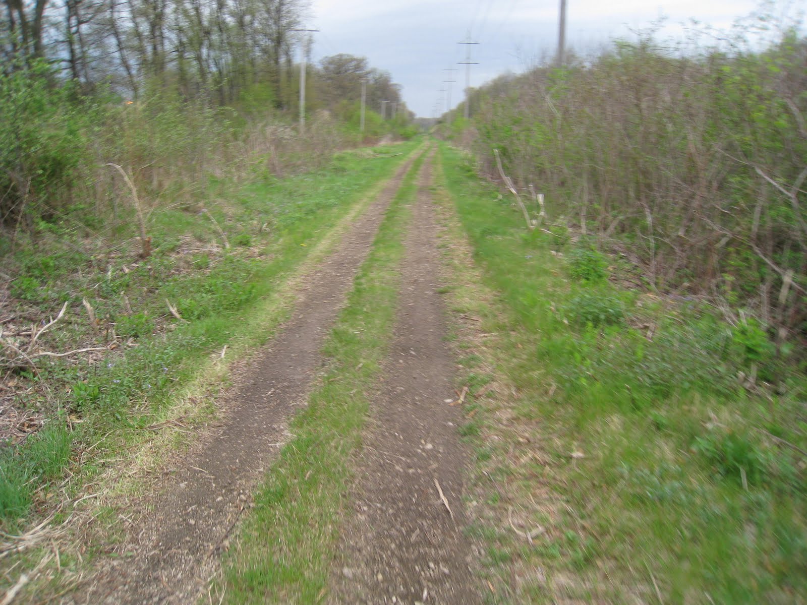
So I made it about 1.6 miles before I decided that I had grossly underestimated the difficulty of this trail. Different planning will be needed for this part of the GIT. I will have to set aside one weekend just for this 22 miles of trail due to its divots, ponds, swamps and creeks that they like to call a path. I will have to strip the bike of panniers and bags and I will strap a waterproof bag I used for white water rafting to the pannier rack. I figger i will have to use an old blanket on the drivers seat in my car so when I finish the path the mud wont get all over the car. I will have to triple bag my camera if I am going to plan to take it. I am assuming that as fun as this ride will be, I am sure I will be exhausted when I complete this. Normally I would finish 22 miles in something like two hours or so. But I bet this will take me more like 6-8 hours. Also, I think that since I will be doing the other legs of the GIT trail with my Hybrid Folding bike, I should use it for this ride also. The semislick tires on this bike should probably make it more difficult than if I had used my regular mountain bike with the big knobby tires.
    Overall I was fairly disappointed with this outing. So I decided to stop at a trail that was local. I stopped off at the Meadowdale Raceway Woods Trail. It has a nice long history of use, disuse and misuse. Once the Meadowdale International Raceway, is now Raceway Woods. And the Google image search.


Sunday: Last day of practice run

Okay, just a quick post about my Sunday mileage on my weekend practice run. Decided to ride south on the FRT to the IPP Elgin branch. Took that to the new Stearns Rd. path and to the Bartlett Nature Preserve. I then went back West on the Stearns road trail right past the IPP that I had just been on and down to the Fox River. There I crossed the river on the new Stearns rd. pedestrian and bike bridge and back onto the FRT heading North.  Stats were as follows:
  • Distance traveled 27.28 miles.
  • Average speed 11.1 MPH.
  • Maximum speed 26.3 MPH.
  • Total time wheels were turning 2 hours 27 minutes 15 seconds.
  • Actual time used for trip 2 hours 40 minutes.
Here is a link to a Kane county bike trail map that shows all of the trails I took except the new Stearns Road trail. It seems that no maps have been updated with this new trail yet(as well as the new Strearns Road bridge)!

Thursday, May 5, 2011

Saturday: The 2nd day of practice run

Woke up feeling pretty good and thought about what I would do for some mileage Saturday. So I took the folding bike and headed North on the Fox River Trail.  Cycled 41.5 miles in about three and a half hours. Went North up into the town of McHenry. Didn't  realize I had a significant wind behind me propelling me forward. It was the easiest 20 miles I have ever done. Once I had turned around for the return trip, the head wind started taking its toll immediately. Lesson learned. Check those wind directions and plan accordingly. Here is the Gmaps link to the map of the path I took. While the Gmaps pedometer program shows just over 37 miles, I had taken a bunch of different side paths to make up that other distance. I will add some pics of that trail a bit later.

Wednesday, May 4, 2011

Weekend Practice Run For GIT

GWT in March slop.

I better get splainin the weekend of riding before the next weekend gets here! Heh. As I was mentioning about those intended weekends of riding for the GIT, I decided it would be a good idea to first prove locally that I can withstand a weekend of riding similar to what I am planning.So this last Friday I decided to ride the Western half of the Great Western Trail. It starts in Sycamore and ends in St.Charles Illinois. That part of the trail is advertised as 18 miles long. Earlier in spring, way back in March, I had biked the Eastern seven miles of the trail and had found the trail kinda miserable at that time. People had been riding motorized vehicles on there in the fall and spring wet months, leaving ruts and divots in the trail. And parts of the trail really grabbed at the tires and sapped my energy quickly.
    When I got to the trail head in Sycamore, the trail looked fairly quiet. So I hopped on my Montague/Swiss Bike TX Folding bike and began pedaling. There were some very interesting cement obelisk type mile markers in the Dekalb County part of the trail. The one shown in the pic has "C55" on it.  Since it is only 18 miles to the end of the Western half of the GWT, I am assuming this refers to the distance to either Chicago or the Eastern end of the East half of the GWT. The interesting mile markers stopped once I entered Kane county.  So the first nine miles of the trail were a loose almost sand sized gravel. The next two miles were paved. That was the area that includes the old railroad bridge over Rte. 47. It was weird that during that two miles of paved trail is when I got a chance to try out my newly installed Mister Tuffy strips in my tires. Something attempted to jam itself under my rear tire as I was cruising at about 17 mph. It gave the bike a jolt and I heard a loud pop. So I looked left to see something shoot out from under the tire and fly about 50 yards away. I thought I had a flat coming for sure. Shortly after that scare the trail returned to a sand mixed with clay for the rest of the trail. Here are the stats for the ride:
  • Distance traveled 18.36 miles in total.
  • Average speed 12.2 mph.
  • Max speed 20.0 mph.
  • Total ride time 1 hour 30 minutes 8 seconds.
  • Actual time 1 hour 55 minutes.
  • Trace path map of trail ridden
 Here is a few links for the Great Western Trail:

GWT and other trails on Google maps

Friends Of The Great Western Trails
 
I decided that 18.36 miles wasn't very representative of a typical day on the GIT that I am planning. And I still felt pretty energetic.So I decided to head across the street from the GWT trail end to Leroy Oaks Park.
Silver Glenn Rd. bike bridge.
A trail runs through it and connects with the Randall and Silver Glenn Trails which in turn will connect with the Fox River Trail via John Duerr Park. So once I got to Silver Glen Rd. I took their fantastic new Biking/jogging/etc bridge over the busy Randall Rd and continued to John Duerr Park. Once in the JD Park I used the FRT to take me a very short distance to the new Stearns Rd Bridge complete with its own pedestrian bridge. The Stearns Rd. trail leads to the Illinois Prairie Path. I took that as far as the Dupage County line and turned back to complete the round trip. Here is the stats for that ride:
  • Total distance round trip 22.09 miles.
  • Average speed 10.9 mph.
  • Max speed 27.9 mph.
  • Total ride time  2 hours 56 seconds.
  • Actual ride time 2 hours 20 minutes.
  • Trace path map of trail ridden.
  •  
    The Google map has not been updated with the new Stearns Rd. Trail. So my path taken seems to show me in some areas without an apparent trail.
    Total distance traveled for the day was 40.45 miles.

Tuesday, May 3, 2011

Riding Plans For the Summer

Grand Illinois Trail.
 What is GIT? That would be the Grand Illinois Trail .  I will be planning two to four day weekends of riding all summer until I finish the 550-650 miles of trail. The blue marks on the map are checkpoints from the Trailblazer program sponsored by the DNR. As I had mentioned in an earlier post , some of the indicated paths and directions in these GIT maps and cue sheets, instructions, etc, should not be blindly trusted. Much research will be needed in order to have my ducks in a row for each weekend that I plan.
Pecatonica Prairie Path
     The next sketchy area that I need to check out will be the Pecatonica Prairie Path. It is 18 miles of what I am calling "Rails to Utility Company to Trails". Apparently after a railroad had handed off the rights to some utility company, the new owners have allowed a trail to be placed alongside of their power lines. But while all this transpired the trail has become purportedly overgrown and unfeasible to many riders in the past as part of their GIT experience. Over this last winter I had run into some kind of postings on the net of progress being made to renovate that trail, possibly with state funding. The trail runs from Freeport to Rockford Illinois. My Illinois Bicycle Trails book lists the trail condition as ballast, grass and dirt. Gonna have to drive up there soon and make a small round trip of it. Am thinking I will recon this area with the mountain bike instead of the hybrid folding bike. Google Maps approximates the trail to be like 22+ miles.

Monday, May 2, 2011

Long Prairie Trail


Looking East on trail in Capron.

As far West as I biked.

So this is a continuation of my ride on the same day as all the Stone Mill Trail hoopla. To speed things up, I rode my car on the discussed route of the GIT cue sheet for the area(Hebron to Capron). Once the road finally intersected bike trail again, I found that the trail didnt just go West but also East. But according to maps, I knew it concluded as a trail head on another side street just a few miles to the East. Here is a map of the trail that I rode that day. I started at the maps mile 2 marker and went West to Caledonia and then back to Capron. Then I went East to see the trail head.
Beverly the ITC lady was here.

Side By Side sign

Side By Side Cycle shop.
Sign at the trail head at East end.

Placard on trail.
     When I had parked in Capron before I went down the trail, I decided to stop in to the bike shop I had heard about in someone elses GIT blog from some years ago. The shop was called Side By Side cycles. I met a nice lady named Beverly. She introduced me to a huge stack of freebies regarding trails and such in Illinois. She also told me of her affiliation with the Illinois Trails Conservancy and I promised I would become a member. I gotta get movin on that and sign up NOW!  When I got done with the bike ride I took a few pics of the storefront for posterity.
    One of the accompanying pictures is of a placard from the bike trail that describes the history and eventual demise of the railroad that used to be where the trail now stands.
 
Bridge on Trail East of Capron